After nearly 30 years of developing and attempting to comply with MS4 permit requirements, how far have our methods evolved to effectively determine if urban stormwater is any cleaner?
The Clean Water Act requires large urban public land owners like cities, counties, departments of transportation and universities, to mitigate the water quality impacts of their jurisdictional lands on local waterways. State-issued MS4 permits are the common stormwater regulatory mechanism by which these requirements are imposed. While clean stormwater is the desired outcome, as a nation, our communities have spent billions of dollars over nearly 30 years on compliance to the minimum extent practical with MS4 regulations. Today, most MS4 stormwater programs have minimal capacity to answer the most fundamental question: “Is urban stormwater any cleaner?”

Regardless of the field or application, progress toward any goal cannot be measured if progress cannot be quantified. The 2NDNATURE Software team is committed to developing the scientific basis and supporting methods for communities and their respective MS4 stormwater programs to answer this clean water question. To validate our scientific quantification methods, we publish them in peer-reviewed scientific journals. We then make our science accessible to MS4 stormwater programs across the country by embedding our proven science in a cloud-based software platform. 2NDNATURE’s most recent publication in the journal, Water, details our unique methods that allow the quantification and tracking of the water quality benefits of green infrastructure implementation.
”Today, most programs have minimal capacity to answer the most fundamental question: “Is urban stormwater any cleaner?”
The 2NDNATURE urban pollutant loading methodology trades time for space. We do this by computationally simplifying time while preserving the spatial granularity of the urban landscape for which we have the detailed spatial data to support. Traditional urban stormwater modeling methods rely on continuous simulation over a 30-year time series on hourly intervals. That’s over 250,000 time steps, and requires a lot of computational power we don’t need. (The 2NDNATURE approach requires only 5 rainfall inputs to represent the same 30-year record.) If the purpose of a pollutant load reduction model is to quantify and track the water quality benefits of urban land management practices, then we must be able to measure and report changes as a result of the land management practices. We want to avoid claiming that stormwater pollution declined just because it rained less last year.
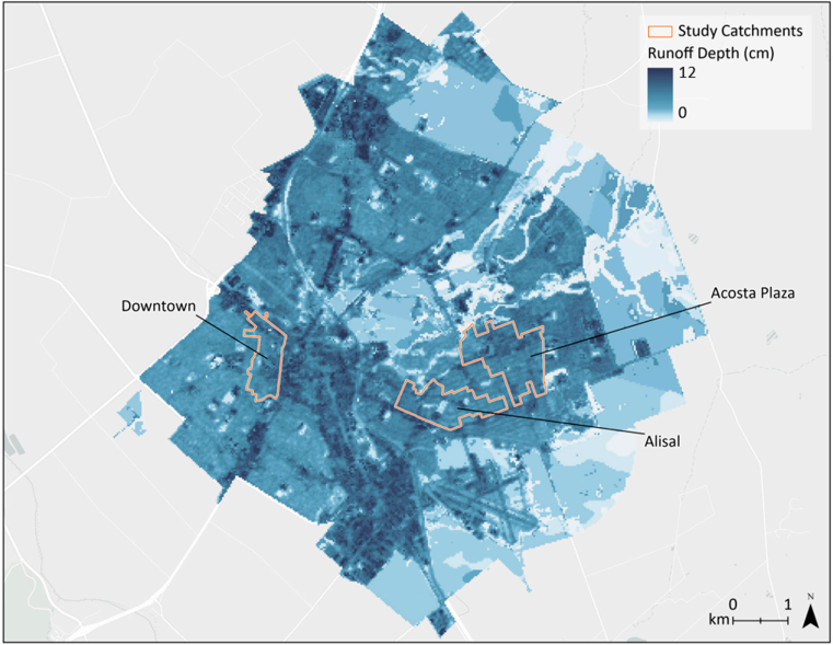
Similarly, common stormwater modelling methods use hydrologic response units, where common land use, soils and landscape types are lumped, mixed and matched , thus the location of these combinations is not explicitly preserved. The lack of spatial preservation of the urban landscape makes the modelling of the water quality benefit of specific green infrastructure assets distributed throughout a specific urban drainage extremely challenging. All 2NDNATURE computations are location-specific (i.e. spatially explicit), leveraging the accurate high-resolution spatial data sources that are publically available and free to use. The quality of these spatial datasets continue to improve as a result of rapidly advancing technologies. As the newest 2NDNATURE peer-reviewed article outlines, we have demonstrated our modelling predictions are within 10% of measured annual urban drainage volumes.
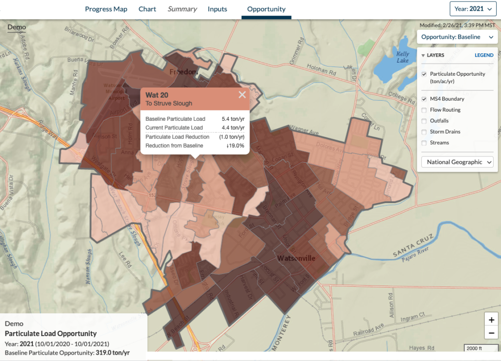
We use publicly available spatial datasets to model the “baseline”, which is the expected annual runoff and pollutant loading from the urban landscape without any stormwater controls in place. Then, our customers inventory their stormwater control measures (i.e. structural and non-structural BMPs), conduct condition assessments and other inspections, document maintenance activities, and perform other required activities per their MS4 permits. Our customers are completing similar inspection, enforcement, and maintenance tasks as they have always been, but now, they enter the required data directly into the 2NDNATURE platform using our mobile field applications. 2NDNATURE’s system-level understanding of data — how, and which collected data must be managed, analyzed, and reported to inform stormwater program decisions and demonstrate regulatory compliance — enables us to immediately transform our customers’ data into shareable, reliable information.
“Now that we have a consistent data schema and accounting system for MS4 stormwater programs, we can set meaningful goals, transparently track our progress, learn and adapt on our journey toward clean stormwater.”
Our cloud-based approach makes our purpose-built, scientific methods accessible and scalable. The use of maps makes complex information available to a wide array of audiences. Cloud-based computing allows us to scale our clean water accounting instantaneously across different spatial scales, expanding clean water outcomes from one green infrastructure asset, to all those within an urban drainage, to all assets within a municipality, a watershed, a state, and beyond.
Now that we have a consistent data schema and accounting system for MS4 stormwater programs, we can set meaningful goals, transparently track our progress, learn and adapt on our journey toward clean stormwater.