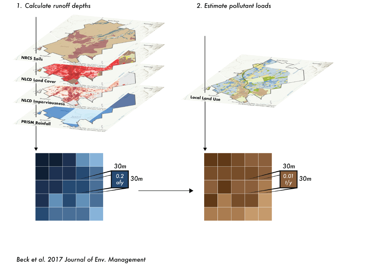
2NFORM Module

Scenario Planning

Model the environmental benefits of your watershed plan

Identify specific stormwater management strategies and practices that will be necessary over the long term to attain specific water quality protection requirements.

Conceptual Icon

Scientific

Analytic modeling based on our published peer-reviewed science.

Conceptual Icon

Forecast

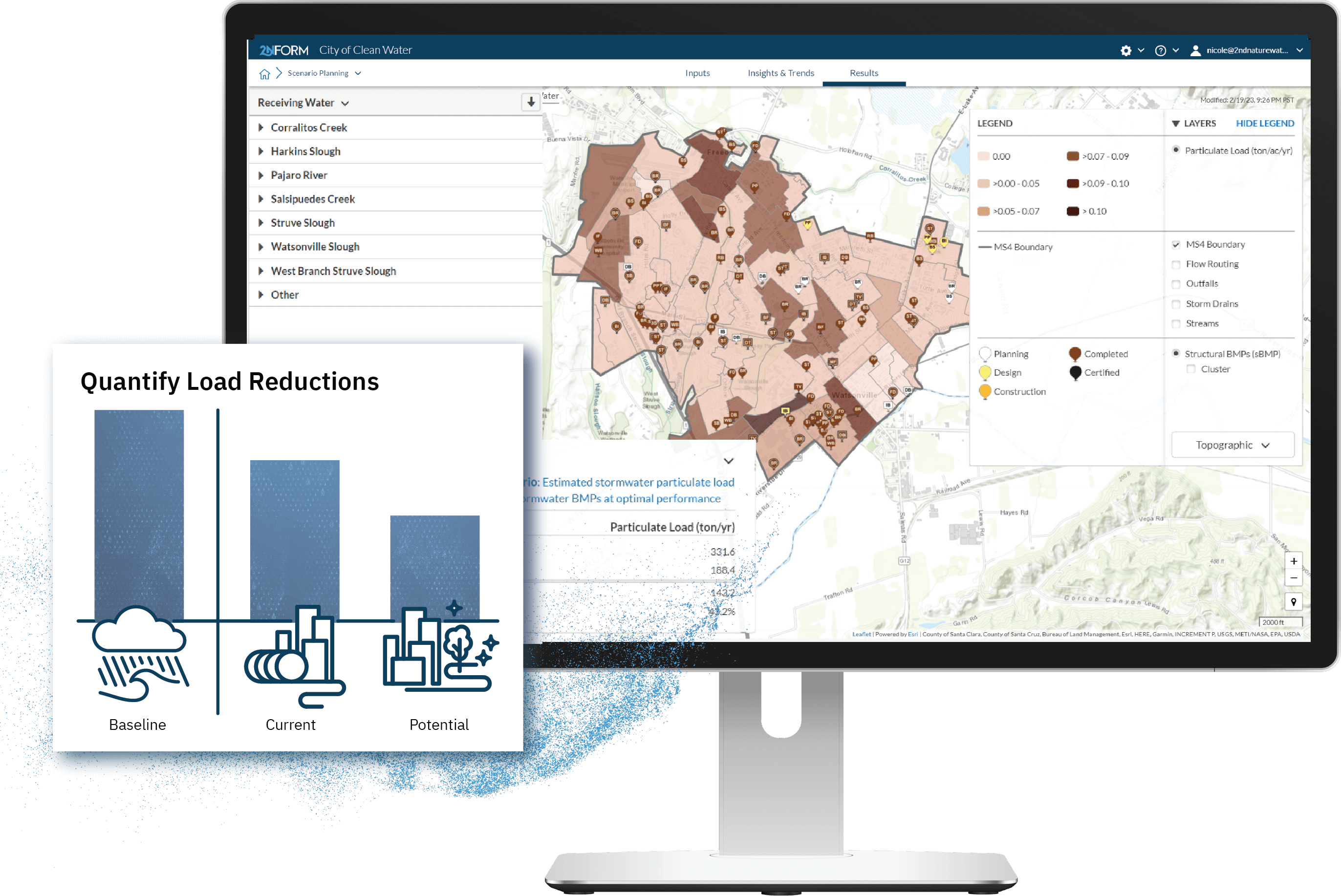
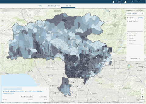
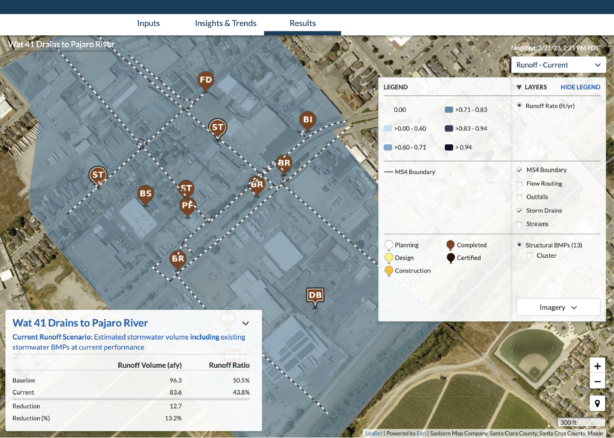
Predict the water quality benefits of your watershed plan with precision.

Conceptual Icon

Optimize

Make informed investment choices to optimize returns.

Conceptual Illustration

Consensus

Consider and balance diverse stakeholder interests.

Conceptual Icon

Agility

Adjust plan to fit current priorities, conditions, and available funding.

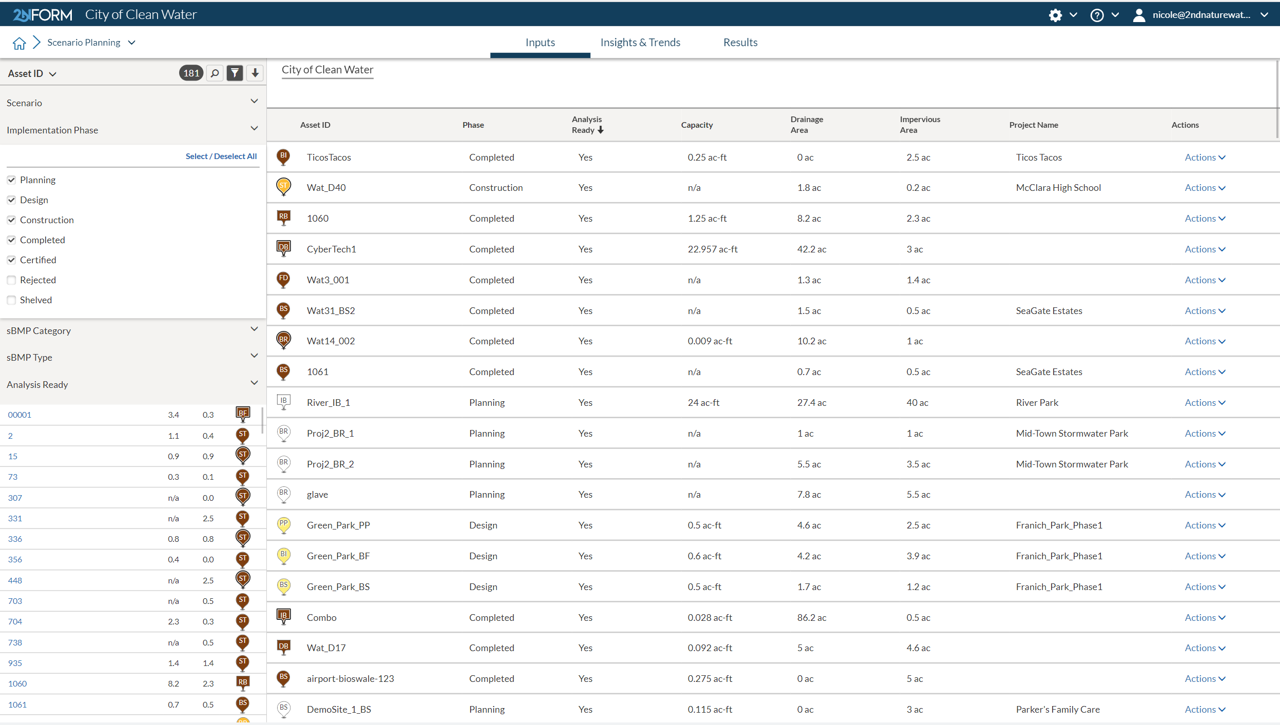
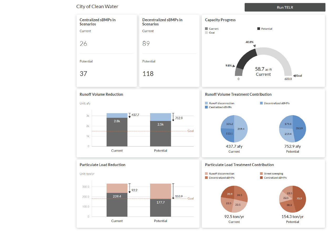
Take control of your stormwater management with our easy-to-use reasonable assurance analysis tool

Delineate the outer boundary of your designated planning area, inclusive of all of the urban land within.

Delineate planning area

Use GIS maps to define your stormwater reduction responsibilities and evaluate local and regional contributions, control measures, and projects.


Use your existing boundary and catchments or, if you don’t have them, we will help you. We recently hosted a webinar called, “ArcGIS Pro Tips: Delineating MS4 Drainage Catchments” which walks you through the process step-by-step.

High spatial resolution stormwater runoff and pollutant modeling estimate based on nationally available 30m raster spatial data

Set baseline

2NFORM will automatically estimate the water quality impact of your planning area on local waterways as if there were no stormwater control measures.


We process nationwide rainfall, topography, land use, and other critical data using patented and peer-reviewed TELR methodology. The fine grained spatial resolution provides you flexibility to do accurate runoff and pollutant accounting on a variety of spatial scales. 

GIS mapping of storm drain lines, structural BMPs and outfall contained within an urban catchment, resulting in a 32% reduction in stormwater pollution from baseline.

Characterize existing conditions and stormwater BMPs

Automatically quantify the benefits of your existing stormwater control measures. Share your local water quality monitoring data, and we’ll calibrate the model to more accurately align with the best available local datasets.

List inventory of current planned structural and non-structural stormwater improvements that can be easily explored with advanced sort and filter functions.

Demonstrate How Management Actions Will Achieve Goals

Use your inventory of planned investments to illustrate how your stormwater plans will mitigate the impact of urban landscape, reduce pollutant loading and take credit for making progress that aligns with TMDL objectives.

Verifiable results

Leverage your investments in water quality monitoring to verify that your predicted load reductions were achieved.


Learn how the City of Salinas is making the most of their Water Quality Monitoring MS4 Permit Requirements with 2NFORM.

Dashboard summarizing the existing and planned stormwater investments and associated volume and pollution reductions expected.

Visualize Transparent Progress

Prebuilt dashboards and reports streamline annual reporting and allow you to manage your program and communicate quantitative and defensible water quality improvement progress to a variety of stakeholders.

Learn more about the science

An urban runoff model designed to inform stormwater management decisions

View scientific publication

Aligning Stormwater Monitoring Datasets with Priority Management Questions

View scientific publication

Assessing the Feasibility of a Cloud-Based, Spatially Distributed Modeling Approach for Tracking Green Stormwater Infrastructure Runoff Reductions

View scientific publication

Built in Capabilities

MS4 compliance reporting

Mapping & GIS features

Data-driven insights

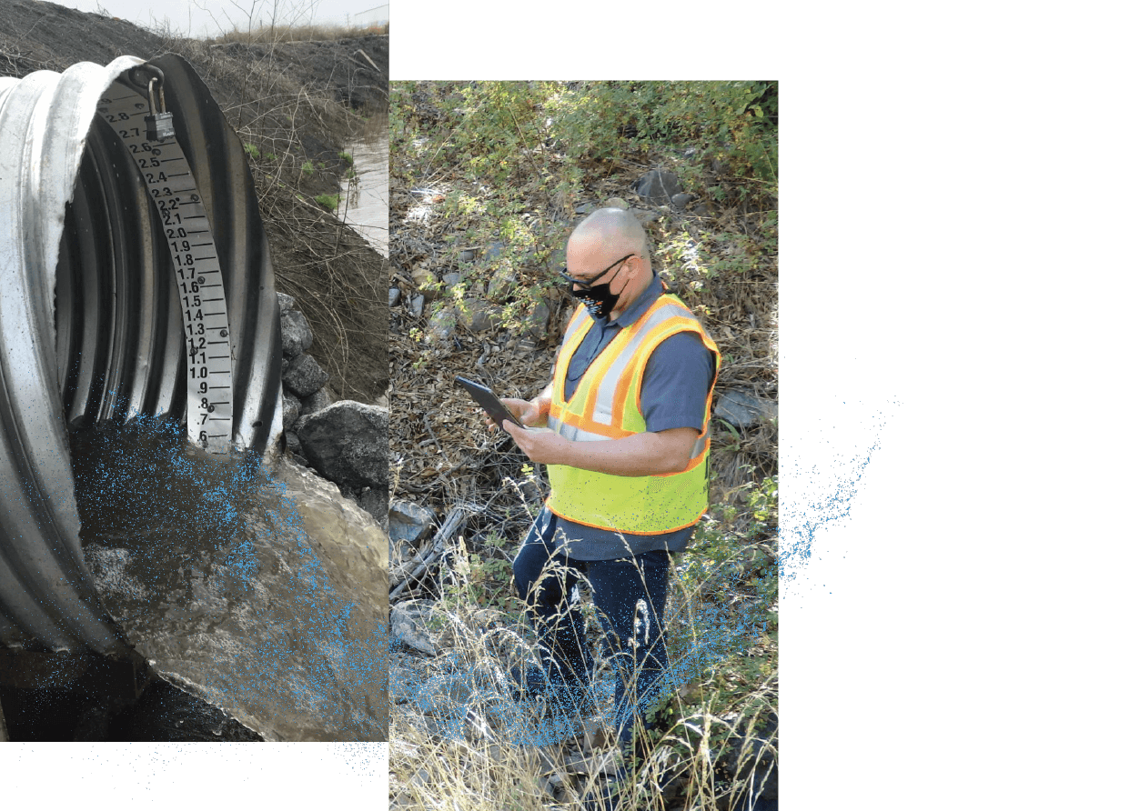
Smartphones, not clipboards

Schedule and track Work

Streamlined compliance reporting

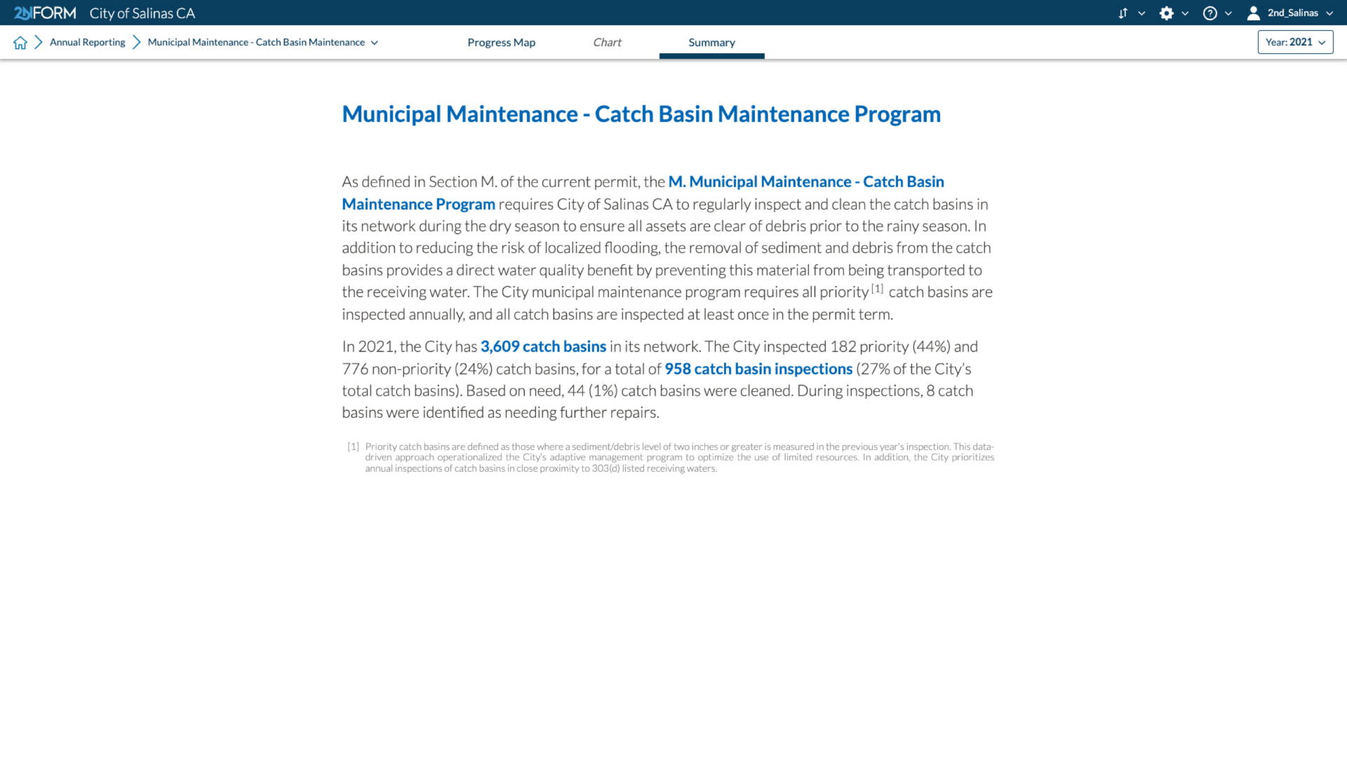
2NFORM streamlines the compilation of your MS4 annual report by summarizing the data your team has collected throughout the year into the relevant section of your permit. The software generates maps, tables and concise narratives populated with program details to summarize program progress and clean water impact of your program efforts.


2NFORM allows you to spend more time on strategic stormwater management and  less time reporting to your regulator.

2NFORM stormwater compliance software inputs your numbers into narrative summaries for your annual reports
2NFORM Works In Tandem with ArcGIS to Unlock Endless Possibilities

ArcGIS Integration

Better together

Use ArcGIS with 2NFORM to accelerate your journey toward less polluted waterways, less flooding, and more resilient stormwater management. 

Leverage the breadth of ArcGIS products to make the most of your stormwater data. Use ArcGIS Field Maps to display and collect information. ArcGIS Dashboards let you monitor and share stormwater information. With ArcGIS Hub Premium you can inform and collaborate with stakeholders and the community. The possibilities are endless. 

More 2NFORM Modules you may like

Project Delivery icon

Project Delivery

Create a digital portfolio of stormwater projects from concept to delivery

View module
2NFORM Structural BMP Diagnostics module icon

Structural BMP Diagnostics Module

Inventory and monitor public and private sBMPs

View module
2NFORM Municipal Maintenance module icon

Municipal Maintenance Module

Keep your house in order by inventorying assets and optimizing operations

View module
2NFORM Post-Construction module icon

Post-Construction Module

Track essential documentation of private stormwater assets

View module

Let us help you map a better way

Book a personalized demo to see how our products provide the visibility you need to streamline compliance, achieve your goals, and focus your energy on clean waterways.