What if the biggest stormwater compliance risk isn’t missing work, but being unable to connect completed work to the right place, asset, and permit commitment? These stormwater compliance data challenges often start with records scattered across spreadsheets, email, maps, and separate systems. The work may be happening, but its evidence and context can be difficult to retrieve when reporting or review deadlines approach.
That disconnect is familiar to MS4 teams managing complex requirements with limited staff time. When activity logs, inspection records, follow-up actions, and location data don’t align, routine quality checks become harder and decisions are more difficult to support. A reliable process needs more than complete records. It needs clear ownership, traceable evidence, and a consistent link between each activity and the relevant location or asset.
This article identifies where stormwater compliance data breaks down, how to prioritize gaps by risk, and which repeatable practices can strengthen data quality. It also explains how connected spatial information can support clearer MS4 reporting, more accountable workflows, and better-informed stormwater investment.
Key Takeaways
- Stormwater compliance data challenges often begin well before reporting, when records, responsibilities, and evidence are spread across disconnected workflows.
- Trace failures from field collection through retrieval to find where inconsistent dates, units, definitions, or status values weaken records.
- Prioritize gaps by completeness, reliability, traceability, location, and operational consequence so urgent evidence needs get attention first.
- Build practical data habits by defining essential fields, assigning owners, standardizing collection, validating records, and reviewing gaps.
- Connect activities, assets, locations, and follow-up through GIS-enabled workflows to support clearer MS4 decisions without relying on technology to replace sound practices.
Why stormwater compliance data challenges start before reporting
Stormwater compliance data challenges are gaps that make it difficult to track program activities, preserve supporting evidence, or make permit-related decisions reliably. They often surface at reporting time but begin earlier: records may be dispersed across spreadsheets, email, paper forms, maps, and department-specific systems. Limited staff capacity, shifting responsibilities, and recurring deadlines make it harder to keep information consistent as work moves between people and teams.
More data alone won’t solve the problem. A field form may capture an inspection, for example, but leave out the asset location, responsible staff member, date, supporting evidence, or follow-up status. Without that context, the record is difficult to compare, retrieve, and act on. A usable compliance record has a location, an owner, a date, evidence, and a status.
The work spans connected activities, from maintaining assets to documenting program actions. A general overview of stormwater management helps show why records can cover varied practices and impacts. For MS4 teams, the practical task is to capture the information needed for their program and applicable permit, not simply accumulate files.
Where MS4 program information becomes disconnected
Information can fragment as work passes from field staff to program managers, departments, or contractors. A paper inspection may be entered into a spreadsheet, while photographs remain in email and the asset location sits on a separate map. Each handoff risks losing context, such as which site a photo documents or who owns the next action.
Duplicated and missing records create different burdens. Duplicates require staff to reconcile versions and decide which entry is current. Missing records require them to search across systems or determine whether the activity was documented at all. Both consume time, but missing records can also leave a critical evidence gap.
Why data gaps affect more than annual reporting
Incomplete records can delay follow-up, obscure asset condition, and limit visibility into whether program activities are being completed. Without a clear date, location, or supporting evidence, staff may struggle to verify what happened, where it happened, and whether an issue was resolved. That weakens day-to-day coordination as well as reporting preparation.
Permit obligations differ, so use the applicable permit language to determine what information and evidence your program needs to retain. Then connect those requirements to consistent records and clear ownership. This gives staff a practical basis for tracking work throughout the year, rather than reconstructing its history at a deadline.
Trace stormwater data failures across collection, location, and evidence
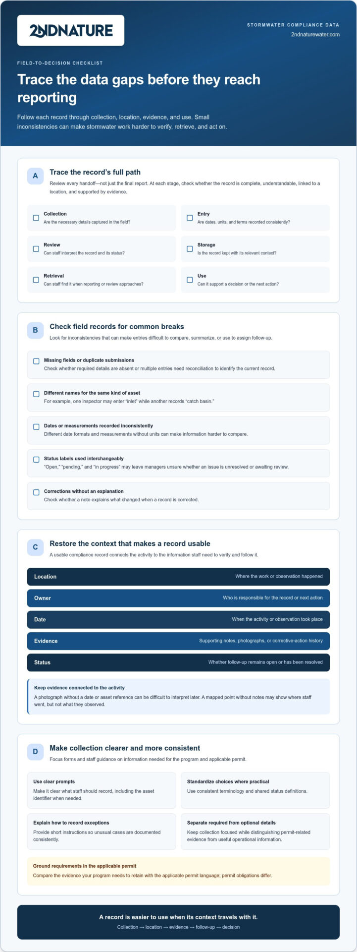
Data quality can break down at every handoff, from field collection to the moment a record informs a decision. Review the full path: collection, entry, review, storage, retrieval, and use. At each stage, ask whether the record is complete, understandable, connected to a location, and supported by evidence. A stormwater record loses operational value when teams cannot verify what happened, where, and when.
Small inconsistencies compound. One inspector may record an asset as “inlet,” another as “catch basin.” Dates may use different formats, measurements may lack units, and status labels such as “open,” “pending,” and “in progress” may be used interchangeably. Those differences make records harder to compare, summarize, or use to assign the next action.
Find completeness and consistency problems in field records
Review sample forms and entries for missing fields, duplicate submissions, inconsistent terminology, and corrections without a note explaining what changed. A form that asks for a location but not an asset identifier may capture where staff were without making clear which structure they inspected. A status field with no shared definitions can leave managers unsure whether an issue is unresolved or simply awaiting review.
Form design and staff training shape record quality. Use clear prompts, consistent choices where practical, and short instructions for recording exceptions. Separate information needed to document permit-related work from optional operational details, then compare required evidence with the applicable permit language. This keeps collection focused without treating every useful detail as a formal requirement.
Restore location and evidence to asset and activity records
Spatial context turns an isolated observation into information staff can act on. Link an inspection or maintenance record to a mapped asset, site, or drainage area where applicable. Then a repeat visit can draw on prior observations, while managers can see where follow-up remains open and compare activity across locations.
Evidence should support the activity it describes. Depending on the task and applicable requirements, that may include inspection notes, photographs, dates, or a history of corrective actions. A photograph stored without a date or asset reference can be difficult to interpret later. A mapped point without notes may show where staff went, but not what they observed.
Disconnected location data adds friction to repeat inspections and follow-up prioritization. Staff may need to reconcile map layers, logs, and folders before confirming an asset’s history. Trace a few recent records across the workflow to find where location, evidence, or status becomes unclear. That review can reveal whether the underlying issue is collection, data entry, review, storage, retrieval, or how teams use the information.
Prioritize stormwater compliance data gaps by risk and consequence
Not every data issue carries the same consequence. A missing record tied to a permit commitment may need prompt attention; a minor naming inconsistency may create extra work without undermining evidence. To rank stormwater compliance data challenges, assess each priority record set across five dimensions: completeness, reliability, traceability, location, and operational consequence. Use permit commitments and internal program priorities to decide what warrants urgent action. There’s no universal risk threshold that fits every MS4 program.
Use a repeatable diagnostic for each priority record set
Sample records from a specific activity, such as inspections or maintenance, and ask whether each is complete, attributable to an owner, dated, spatially located, and retrievable. Compare the record with its source evidence and applicable program requirements. Document who maintains the data, who validates it, and who acts on the result. A clear ownership chain helps teams distinguish an isolated entry error from a recurring process failure.
Then assign a practical priority based on both evidence and consequence. A record that lacks permit-linked evidence or cannot be traced to an activity may require immediate review. A consistent but inefficient process, such as duplicate entry, may be a workflow improvement. Use your own permit language and program priorities to distinguish urgent exposure from lower-risk friction.
Distinguish compliance exposure from workflow friction
Keep evidence gaps separate from process inefficiencies. Both deserve attention, but they call for different first steps. Use this comparison to direct the diagnosis:
- Missing permit-linked evidence: The program may be unable to support a required activity. First, compare the applicable commitment with the source records and identify the missing evidence.
- Unclear activity history or undocumented corrections: Staff may be unable to explain what changed or verify the sequence of work. First, trace a sample record from its original entry through review and correction.
- Duplicate entry or difficult retrieval: Staff spend time reconciling versions or searching across systems. First, map where information is entered, stored, and retrieved, then identify duplicate steps.
- Incomplete or unreliable location data: Teams may struggle to connect an observation to an asset or prioritize follow-up. First, compare mapped records with source notes and known asset references.
Software can help organize records and make gaps visible, but it can’t determine who owns a record or make inconsistent collection practices reliable on its own. Set roles, definitions, and validation steps first. Then use a repeatable risk review to direct limited staff time toward evidence that matters most and improvements that will reduce recurring friction.
Build repeatable stormwater data practices without adding unnecessary work
Good data practices should make required work easier to document, not add a second administrative process. Focus standards on permit-linked evidence and recurring decisions, such as whether an inspection needs follow-up or an asset requires attention. A practical sequence helps teams improve consistency while working within limited staff capacity.
- Define the fields. Identify the minimum information needed for each record type, based on applicable permit commitments and actual program workflows.
- Assign owners. Name who enters, reviews, and corrects records, and who is responsible for acting on identified issues.
- Standardize collection. Use shared definitions, status values, date formats, and units across forms and teams.
- Validate records. Check entries near the time of collection so omissions and unclear values can be corrected while context is available.
- Review gaps. Look for recurring problems and adjust forms, instructions, or handoffs where they originate.
Set shared definitions, owners, and minimum data fields
Define common terms for assets, inspections, activities, and corrective actions. For example, distinguish a newly reported issue from one assigned for follow-up and one confirmed as resolved. Clear ownership and consistent definitions make stormwater records easier to validate and reuse. Assign responsibility across relevant roles, then set the minimum record fields needed to support required evidence and routine program decisions. Avoid collecting extra information unless it serves a defined operational purpose.
Create a steady quality-control and retrieval routine
Build lightweight checks into the workflow rather than saving every correction for reporting season. At a regular interval, scan for missing fields, duplicate records, invalid dates, and unresolved follow-up. Keep source evidence and correction history connected to the record so reviewers can understand what changed and why. When a gap appears, direct it to the person responsible for correction or action.
Test the process by selecting an activity and asking staff to retrieve its record, supporting evidence, and follow-up history. If they need to search several folders or rely on personal knowledge, improve the storage or handoff process. Repeat the test after changes to see whether retrieval has become more consistent. These routines make data quality part of daily program operations, not a separate reporting exercise.
For a GIS-powered approach to connecting MS4 records with locations and assets, explore GIS-enabled stormwater workflows.
Connect stormwater compliance data to GIS-enabled MS4 workflows
Once a team has identified its highest-priority gaps, it can assess whether a GIS-connected workflow would address them. Spatially connected records can bring a mapped location, related asset, inspection, evidence, and follow-up into a shared operational context. That connection is useful when staff need to locate an activity’s history, understand which asset it concerns, or see what action remains open.
Technology supports sound data practices; it doesn’t replace clear ownership, consistent definitions, or interpretation of applicable permit requirements. Start with the program’s commitments and daily processes, then evaluate whether a workflow makes the needed information easier to record, retrieve, and use. This keeps the decision focused on diagnosed stormwater compliance data challenges, not on adopting technology for its own sake.
Evaluate whether a connected workflow addresses the diagnosed gap
Match the workflow to a defined need, such as asset tracking, reporting, or BMP diagnostics. Check whether staff can view location, record history, supporting evidence, and follow-up together where relevant. Also consider whether the workflow fits existing roles and collection practices. A system that organizes information but leaves ownership unclear may preserve the same handoff problems in a new place.
Keep the evaluation grounded in applicable permit commitments and operational priorities. For example, if staff struggle to retrieve inspection evidence for a mapped asset, assess how the workflow connects those records and supports retrieval. If the main issue is inconsistent status terminology, establish shared definitions first. The right approach addresses the cause of the gap, not just its visible symptoms.
Apply the framework to 2NFORM and municipal work
2NFORM is a GIS-powered option for municipal MS4 compliance workflows. It supports reporting, asset tracking, and BMP diagnostics, along with program areas such as maintenance, post-construction, and illicit discharge. Evaluate these capabilities against your team’s needs: which records must connect, which staff use them, and which recurring decisions should the workflow support?
Make the next step small and concrete. Map one recurring workflow, such as an inspection followed by corrective action. Note where the location, asset information, evidence, ownership, or status currently becomes disconnected. That map gives the team a practical basis for refining its data practices and assessing whether a connected workflow fits. Explore how 2NFORM supports connected stormwater compliance work.
Make compliance data work harder for your MS4 program
Stormwater compliance data challenges are easier to manage when teams address them before reporting deadlines. Start by tracing records from collection through use, then prioritize gaps according to evidence needs and operational consequences. Clear field definitions, assigned ownership, and routine quality checks help preserve context and make information easier to validate and retrieve.
GIS-connected workflows can bring locations, assets, inspections, evidence, and follow-up into view together. The technology works best when it supports consistent practices and clear responsibilities, while staff continue to interpret and apply their own permit requirements.
2NFORM supports GIS-powered municipal MS4 compliance, asset tracking, and reporting workflows. Explore 2NFORM for your municipal MS4 workflows.
Begin with one recurring workflow and identify where records lose context. A focused review can reveal practical improvements and help your team build more defensible, useful data practices over time.
Frequently Asked Questions
What are the most common stormwater compliance data challenges?
Common stormwater compliance data challenges include scattered records, missing or inconsistent fields, unclear ownership, weak location links, and evidence that’s difficult to retrieve. Teams may also find duplicate entries, inconsistent status terms, or incomplete histories of follow-up and corrections. These gaps can make it harder to verify activities and prepare reports. Start by tracing a sample record from collection through use to identify where context or evidence is lost.
Why is stormwater compliance data often fragmented across departments?
Stormwater data often becomes fragmented because field staff, program managers, contractors, and other departments use different forms, systems, and handoff processes. An inspection may be recorded in one place, photographs stored elsewhere, and asset information maintained on a map. Changing responsibilities and limited staff capacity can make those divisions harder to manage. Shared definitions, assigned record owners, and clear transfer steps help keep context intact.
How can an MS4 team identify gaps in its stormwater data?
An MS4 team can identify data gaps by sampling records from recurring activities and checking whether each is complete, attributable, dated, located, supported by evidence, and retrievable. Compare each sample with its source documentation and applicable permit or program requirements. Record who enters, validates, and acts on the information. Then prioritize gaps by their potential consequences, addressing missing permit-linked evidence separately from lower-risk workflow inefficiencies.
What data should municipalities track for stormwater compliance?
Municipalities should track information needed to document their applicable permit commitments and support recurring program decisions. Depending on the activity, a record may include its type, date, location, related asset, responsible party, status, supporting notes or evidence, and follow-up history. Requirements vary by permit and program, so use the applicable permit language to determine what must be documented. Keep optional operational details distinct from required compliance evidence.
Can GIS improve stormwater compliance data management?
Yes. GIS can connect stormwater records to mapped locations, assets, and drainage areas, helping staff view inspections, evidence, and follow-up in context. This can make it easier to retrieve an asset’s history or understand where work remains open. GIS-powered 2NFORM supports municipal MS4 compliance workflows, asset tracking, and reporting. The value depends on consistent records and clear responsibilities, not mapping alone.
How can teams improve stormwater data quality without adding more administrative work?
Teams can improve quality by building simple checks into existing collection and review steps. Define the minimum fields needed for permit-linked evidence and routine decisions, assign owners, and standardize terms, dates, and status values. Check for missing fields, duplicates, and unresolved follow-up near the time records are entered, while details are still clear. Focus on recurring errors first instead of creating a separate review process for every record.
Does stormwater compliance software solve data quality problems by itself?
No. Software can organize records, connect information, and make gaps easier to identify, but it can’t establish clear ownership or consistent collection practices on its own. Teams still need shared definitions, role assignments, validation routines, and an understanding of applicable permit requirements. Define those practices first, then assess whether a software workflow supports them. A useful system reinforces sound processes rather than replacing them.