Flood control is crucial to Yavapai County, AZ. With 2NFORM stormwater compliance software, the county has improved flood control substantially.
THE CLIENT
Yavapai County Flood Control District, AZ
Tony Angueira, Stormwater Engineer
Yavapai County is one of the four original Arizona counties formed in September of 1864, one year after the Arizona Territory was established. The County was named after the Yavapai Tribe, whose name means “people of the sun.” With an area of 8,123.5 square miles, Yavapai County is approximately the same size as Massachusetts, and has everything from tall, evergreen mountains to grasslands and desert areas. The Yavapai County Flood Control District was created in December 1981 and charged with minimizing public and private losses from flooding.
THE CHALLENGE
Too Many Databases, Not Enough Flexibility for Effective Flood Control
Tony Angueira, Stormwater Engineer for the Yavapai County Flood Control District in Arizona, had an unusual MS4 boundary: 19 non-conjoined segments that contain well over 250 mapped outfalls along roadside drainages, curbs, gutters, ditches, swales, channels, catch basins, culvers, and storm drains. At least 20% of the outfalls needed to be visually inspected and photographed each year during both dry and wet conditions. The MS4 permit also required Tony to monitor intestinal E.coli bacterial levels by sampling water from selected outfalls.
He needed to get organized. “The biggest challenge was that we used multiple databases and it was really clunky and overly complicated. It took a lot of time,” Tony says. “It took a lot of planning to go out and do inspections and make sure I wasn’t hitting places I’d been before.” He relied on the GIS department to make updates to his maps and run reports in order to know where to go. His job would be a lot easier if he could bring everything together in one centralized system, with interactive GIS-based maps.
Tony needed flexibility: “It was hard to respond to weather events in real time,” Tony says. “Storms can come through that look almost identical on a monitor screen, but the flows may go off in one direction or the other. It ends up being a matter of inches.” Tony had to find a way to ensure he was doing all of the necessary outfall monitoring and tracking, while also taking into account sudden weather changes.
Read more about how Tony is protecting Yavapai County from flood impacts using 2NFORM.
Read nowMost of all, Tony wanted to do his job, and do it well. He’s the only dedicated stormwater person for Yavapai County, and flood control is deeply important to the people who live there, whose homes and businesses may be in danger of being damaged or destroyed by floods. The county is also prone to wildfires, which increase the dangers of both flash flooding and debris flows.
Tony was determined to find a solution that could work with his realities. “It’s Arizona, where rainfall events are scarce. We can’t waste any opportunities.”
OUR SOLUTION
Organize, Centralize, Map
Tony went searching for a technological solution, and he found the 2NDNATURE website. He reached out and started talking to our stormwater experts about 2NFORM, a robust software platform that brings structured data intelligence to MS4 compliance and stormwater management. Foundational modules handle information management and reporting that help move operations towards compliance with MS4 permits. Additional modules empower stormwater managers with advanced analytics and planning capabilities, using existing data to drive actual improvements in water quality.
“The website looked good. The possibilities were intriguing. Everything they said was just what we really needed to hear,” Tony says. “That’s how it turned out, too.”
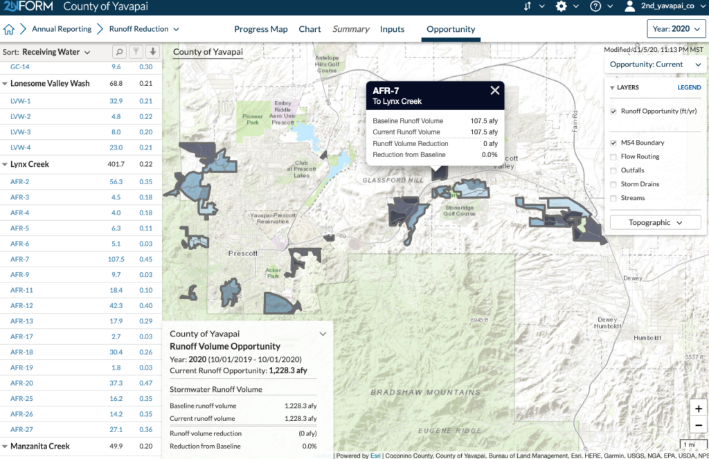
With 2NFORM, Tony gets the benefits of GIS without having to go to his GIS department. 2NFORM shows him his MS4 on an interactive map, built on Esri’s ArcGIS. He can see all of the places he needs to go, and whether they’re due for inspections or not. All of the information he needs is in one centralized platform.
A Growing MS4 with Growing Needs
This is especially important because the Yavapai County MS4 boundaries have recently expanded to nearly double in size, adding to Tony’s responsibilities. He’s figuring out how to manage stormwater across a broader area with different communities and a whole new watershed. Establishing new outfalls, in particular, is a big challenge. “You can’t always determine an outfall in just one rainy season,” Tony says. “You have to see what flows reliably, where the stable flows occur. You can have an area with substantial flow in one year, but that could be an anomaly. The active runoff flow channels sometimes change from year to year.”
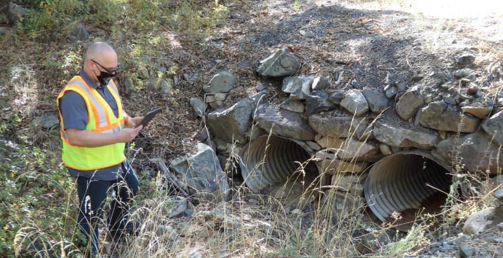
Tony Angueira in the field, using 2NFORM on his mobile device.
In the past, Tony would have had to hire a consultant and have a long-term study done to understand how water flows over and through the landscape. To map new possible outfalls, “We would start with a stack of printed paper maps. Mark our spots with an X, then use trial and error to pinpoint those locations over time.”
2NFORM brings both ease and precision. “With 2NFORM, I can create new outfalls on the fly,” Tony says. “I use a high accuracy, handheld GPS indicator to positively locate what is out there, then add new outfalls in 2NFORM while out in the field. I have the capability to quickly refine or establish the locations of storm drains, culverts, and outfalls to within six decimal points.”
Tony loves having this ability. He can check and re-check whether water flow is an actual outflow over the years. “The goal is continuous improvement,” Tony says. “We’ll have a good, reliable dataset with a degree of confidence that honestly, we wouldn’t have without 2NFORM.”
Solving Stormwater Problems Both Old and New
Tony’s regulators appreciate his easy-to-read annual reports as well. Tony can generate a read-only report straight from 2NFORM, with maps based on Esri’s ArcGIS, charts, graphs, and paragraphs of text that summarize his activities from the year. Tony is encouraging other Arizona stormwater managers to explore technological options like 2NFORM as well. He’s learned a lot by using the software. “I’ve become a far more knowledgeable MS4 operator just by virtue of being a 2NDNATURE customer,” Tony says.
Not only did Tony solve his past problems — decentralized data, difficulties organizing his many required inspections, time consuming annual reports — but he found a better way to manage the new land that came under his purview. And as lone stormwater manager for a growing MS4, Tony enormously appreciates how much time 2NFORM saves him, and the insights it offers.
“There’s no doubt 2NFORM saves me time,” Tony says. “Between the ability to add outfalls on a mobile platform, make changes, respond to where weather events are occurring — all these make it so that I can be out there, right where I want to be. I can be there in time to get samples and gain a better understanding of precisely how, where, and when the flows occur.”
Inspections for Better Flood Control
Most importantly, Tony knows he is helping the residents of Yavapai County. “When I do inspections, I can identify potential flooding problems. I look at the state of infrastructure out there and identify where it is in need of maintenance,” Tony says. “If I didn’t have 2NFORM, I wouldn’t necessarily be able to analyze all of these things with the same level of fidelity, and I don’t know that anyone else would, either.” With 2NFORM, Tony can understand the status of stormwater assets and recommend maintenance. “Without that, we could experience floods and not be aware of resultant changes to the status or condition of our stormwater infrastructure.” He’s protecting his community from flooding with intelligent stormwater management.