In every corner of the United States, the signs of climate change manifest as extreme weather: long periods of drought followed by overwhelming floods. These extreme conditions tax our aging stormwater water systems, especially in urban areas where impermeable surfaces prevent rainwater from naturally replenishing the earth, turning potential life-sustaining water into destructive polluted runoff. This severely risks the health of our environment, economies, and communities.

Rethinking Our Relationship with Rainwater
Nicole Beck, Ph.D., the visionary founder and CEO of 2NDNATURE, took the stage at a TEDx Talk in Santa Cruz, California, to inspire us with groundbreaking ideas on reimagining our relationship with rainwater.
At 2NDNATURE, we harness the power of scientific research and cutting-edge technology to develop innovative and sustainable water management solutions. Our approaches aim to optimize freshwater management and revolutionize how communities engage with this essential resource, thereby improving urban resilience and ecological well-being.
This page offers an in-depth look at our methods and tools, including our pioneering urban runoff modeling system. It showcases stormwater GIS’s positive impact on informing land management decisions. Whether you are a policymaker, an urban planner, or an environmental enthusiast, you’ll find valuable insights and actionable strategies that can be applied to your work or study.
We encourage you to explore the information provided here and consider how these approaches can be integrated into your practices. Learn about the science driving our solutions and connect with us to discuss how we can help you address your community’s water management challenges today.
America’s Swelling Water Crisis
Across the nation, communities face diverse water-related problems that climate change is only exacerbating. As we oscillate between periods of drought and flood, these extremes signal an urgent need to reevaluate our traditional approaches to freshwater in our communities.
The United States has grown accustomed to excessive consumption and inefficient use of its freshwater resources, compounded by rapid urban development. Such practices have strained our water supplies to critical levels. Groundwater, which accounts for 90% of the U.S. freshwater supply, is often drawn unsustainably, leading to depleted aquifers from coast to coast, with countless warning signs in the west and the east. This over-extraction not only jeopardizes water security but also results in an irreversible reduction in the capacity of underground reservoirs, leaving us more vulnerable during increasingly severe drought periods. Future times of drought will amplify our historically poor decisions regarding managing freshwater supplies and elevate scarcity.
We are witnessing an increase in climate-related disasters, particularly during periods of excessive rainfall. Annual precipitation is becoming concentrated in fewer yet more intense events, putting immense pressure on outdated and insufficient stormwater systems and significantly amplifying flood risks in urban areas. Recent events have shown that no community, from San Diego to Flagstaff to Kentucky to Pennsylvania to Vermont, is safe from these escalating hazards.
We can only afford to be reactive for a bit longer. Proactive mitigation actions are crucial for saving money, property, and, most importantly, lives. Proactive investments that build local resilience cost 4 to 6 times less than the price tag for disaster recovery. This figure ignores the unquantifiable amount of human suffering avoided. Global climate change is upon us, and communities have an opportunity to be proactive and adapt to reduce the risk and severity of future catastrophic events.
The Perfect Storm: Pollution, Flooding, Water Scarcity and Beyond
From water scarcity to pollution to flooding, U.S. communities face the perfect storm that climate change will continue to fuel.
According to the EPA, urban stormwater is one of the fastest-growing sources of water pollution in this country. The U.S. urban design strategy is to evacuate polluted urban stormwater out of our cities as quickly as possible and discharge it into local streams, lakes, and other waterways. Decades of expanding urban development have resulted in an expansion of the amount of impervious area draining to legacy stormwater systems, which were not designed to handle the additional volumes.
The typical urban storm sewer system is a network of drop inlets, pipes, channels, and stormwater detention structures. The quality and care of municipal stormwater infrastructure have been a very low priority in most communities. With trillions of dollars of aging infrastructure across the US, national stormwater systems are in critical condition. Most US cities must first complete an inventory of their stormwater systems to estimate and secure the necessary funding to address their backlog of undersized failing infrastructure. Add the increasing frequency of more intense precipitation events due to a rapidly changing climate, and our aging municipal storm sewer systems across the U.S. face the perfect storm and are ill-prepared to drain our cities.
The negative impacts of our urban design strategies extend beyond just flooding and pollution. The blankets of impervious surfaces also result in a widespread disruption of the natural hydrologic cycle in our cities. With many groundwater aquifers relied upon as a critical local freshwater source, our impermeable cities limit any recharge of local groundwater aquifers. Similarly, minimal infiltration disrupts rainwater’s natural subsurface journey to the nearest stream. Promoting infiltration in cities offers protection against flooding and supports vital processes that maintain the health of aquatic ecosystems.
Rethinking Climate Resilience Through Rainwater Management
2NDNATURE is a team of scientists, GIS experts, and software developers. Our mission is to develop the tools Americans need to prepare for the growing impacts of climate change by making better urban land management decisions. We develop peer-reviewed scientific methods and embed them in digital tools to inform effective, locally tailored, climate-resilient rainwater and stormwater management strategies. 2NDNATURE helps communities embrace the untapped potential of rainwater management to boost local resilience. We see an opportunity for the public and private sector to unite around embracing rain as a valuable freshwater source to boost their communities’ resilience to our rapidly changing climate.
Understanding Rain and Runoff – The Challenge and Opportunity
Clean water, a precious resource, descends from the sky directly to us at no cost. Yet, vast expanses of impervious surfaces in U.S. cities block rainwater from seeping into the earth. Consequently, when rain strikes these impermeable areas, as much as 85% of it becomes runoff, in stark contrast to the 60-70% that would be absorbed by the ground if it fell on natural surfaces.
2NDNATURE science fueled a national assessment to document that the amount of runoff in U.S. cities is 20 trillion gallons per year, or 93% of the volume cities consume for municipal and industrial purposes. Rainwater is relatively clean before it hits the roof, driveway, or other surface, but as it flows over the urban landscape, it picks up impurities that rapidly degrade its quality.
By using clean rain that falls in our cities better, we minimize the volume of polluted stormwater runoff local stormwater systems must convey out of our cities. Every drop captured or recharged into the ground lowers downstream flood risk. Rainwater is clean enough to satisfy onsite non-potable uses such as irrigation, industrial processing, and toilet flushing. Yet, rainwater capture is far from mainstream.
Embrace Three Simple Practices
Making better use of rainwater and runoff requires investment in three simple practices. Implemented at scale on both public and private lands, these practices can boost local resilience and help communities better adapt to the rapidly changing climate.
- Capture and Reuse: Collect and reuse rainwater and runoff for non-potable water, and potable water needs to decrease reliance on municipal fresh water supplies. Capture systems can range from on-site solutions to offset property-specific potable consumption or regional collection projects that augment distribution supplies. Treatment may be required, depending upon the end use of the captured water.
- Infiltration and Recharge: Poke as many holes in the blankets of pavement covering our cities as possible to put water back into the ground where it belongs. Solutions that detain and promote infiltration passively percolate runoff, taking advantage of soil’s natural filtration benefits. Active recharge solutions range from localized dry wells to large-scale managed aquifer recharge systems that reduce excess runoff and strategically replenish regional aquifers.
- Urban Greening: Green stormwater infrastructure and natural-based solutions are critical elements to boost local resilience through stormwater management. Solutions ranging from green roofs to rain gardens to constructed wetlands are essential to rapidly greening our cities using regionally appropriate vegetation. Studies reveal staggering temperature disparities between affluent and underserved neighborhoods, directly related to how green they are. Urban greening absorbs runoff, reduces flooding, cools temperatures, supports biodiversity, enhances aesthetics, and makes people happier. By combining urban greening with runoff management solutions, communities can mitigate the deadliest climate change impact, extreme heat.
The Science and Tools Behind Resilient Water Management
2NDNATURE provides the science, geography, and digital tools to inform local and regional rainwater management strategies to determine which of the above practices are best implemented where. We develop peer-reviewed scientific methods and embed them in digital tools to inform effective, locally tailored, climate-resilient rainwater and stormwater management strategies. Our tools provide the public and private land managers a defensible environmental accounting system to track environmental progress and credit effective actions.
Building 2NDNATURE’s Science Legacy
Founded in 2005, 2NDNATURE has a successful track record developing practical decision support tools for policymakers and land managers throughout the U.S.. Our methods unite data, modeling, and maps in practical and efficient ways to make science readily accessible to inform decisions, communicate priorities, set goals, and quantitatively track progress associated with improvements. We focus on developing practical and efficient data collection methods resulting in location-specific precise information that can be scaled over space and time. Our legacy includes work on developing scalable field protocols, analytics, and visualizations for a wide array of landscapes well beyond urban stormwater. Examples of 2NDNATURE research over the last 20 years range from tracking the biogeochemical and ecological health of coastal California lagoons to tools to assess and track the function of riparian zones and stream water quality function from undeveloped backcountry to highly urbanized settings, to agricultural land management strategies to reduce nutrient pollution, to creating fire modeling tools to scope effective fuel management strategies and quantify the avoided financial and ecological impacts of catastrophic fires. We partnered with urban and rural road managers to develop a comprehensive field and mapping system to objectively assess, quantify and track the hydrologic and water quality impacts of urban and rural roads on local waterways.
2NDNATURE’s early urban stormwater-focused science focused on developing monitoring and modeling tools to support the Lake Tahoe Basin Stormwater Crediting Program to Keep Tahoe Blue from 2005-2015. 2NDNATURE led the ideation, data collection protocols, analytics, and reporting formats for the tools used today by the local Tahoe municipalities and regulatory agencies to prioritize investments, model potential water quality benefits, and conduct verification assessments to ensure particularly private parcels, urban roads, and structural stormwater BMPs are maintained property and thus yielding the water quality progress claimed. 2NDNATURE led the design of practical urban catchment data collection, management, and reporting techniques to reduce costs and increase the power of municipal water quality monitoring programs to ensure they generate data that directly informs the collective effectiveness of their stormwater improvement actions. Our smart water sampler design has been patented and used extensively for urban outfall water quality monitoring.
All of the early 2NDNATURE applied stormwater science work contributed to our creation of protocols and analytical frameworks best suited for local governments to make the most of the MS4 permit requirements by collecting better data more efficiently and, in the process, arming them with insights about the local landscape to build effective strategies to reduce pollution, flooding and other avoidable negative impacts of urban land use on the local environment. The 2NDNATURE team prides itself on advancing the field of applied stormwater science and making our science accessible to those who need it.
Tool to Estimate Load Reduction (TELR)
2NDNATURE created TELR to fill a critical technical gap in the stormwater industry, a defensible and scalable methodology to inform urban watershed planning and defensibly account for runoff and pollution reduction benefits of stormwater management improvements. TELR methods have been extensively peer-reviewed to ensure technical validity while honoring 2NDNATUREs commitment to open science. We created TELR as a defensible and scalable water accounting system to track the benefits of resilient water management investments by private landowners or public agencies.
TELR is a GIS-based urban stormwater runoff model that uses local land use and other readily available high-resolution spatial data as inputs to generate runoff and stormwater pollution estimates at the spatial resolution of the available data (Beck et al. 2017). Mapped locations and basic design specifications or other characteristics of stormwater control structures like capture and reuse, infiltration and green infrastructure systems (Conley et al. 2021), runoff disconnection actions, or even street sweeping practices are represented on the landscape and the volume and pollution benefits modeled using TELR methods.
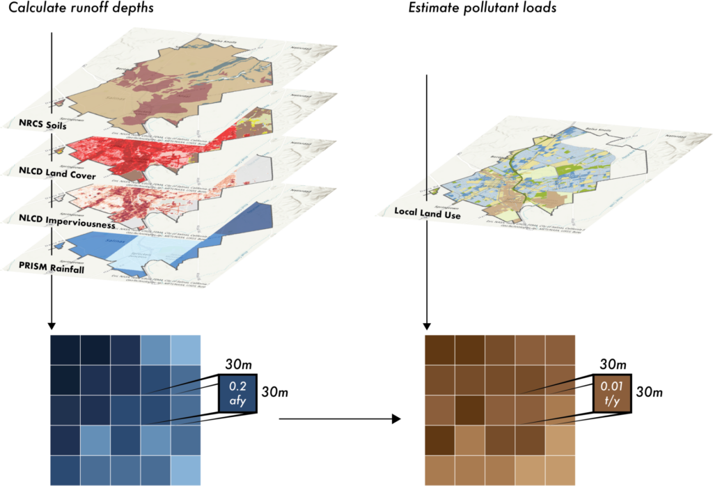
TELR is a flexible framework that can predict runoff and pollution loading in various spatial and temporal scales. Model outputs can be validated using measured data by aligning precipitation inputs with monitored periods. TELR runoff results have been validated using measured data across various spatial and temporal scales, from urban catchments to USGS-gauged watersheds (Conley et al. 2022). TELR algorithms have been tuned using the best available science and research to reliably represent the performance decay of infiltration systems commonly constructed to control urban stormwater (Conley et al. 2000).
Obtaining TELR results requires no special training and is available to run within 2NDNATURE’s web-based software products (2NFORM and Rainsteward). Each software solution applies the TELR methods to generate stormwater runoff and pollutant loading estimates, with the outputs summarized in simple-to-interpret maps to inform investment strategies and graphs to summarize environmental progress. TELR methods generate results for municipal urban land managers to identify stormwater impact mitigation opportunities, assess different stormwater improvement scenarios, and account for and track progress toward city and watershed stormwater runoff and pollution reduction goals.
Climate Adjusted Models
As shifting rainfall patterns deliver more intense storms to cities, local policymakers are adjusting local stormwater design requirements for new and redevelopment to prepare for the increased runoff (Chapel Hill news April 2024).
2NDNATURE combined our TELR methods with downscaled regional climate model outputs to predict how climate change will impact local and regional stormwater runoff patterns across the United States (Nodine et al. 2024; Nature Scientific Reports). While the specifics vary across the country’s climatic conditions, the general expectation is that runoff will increase disproportionately more than total annual precipitation. Generating localized results provides invaluable projections for communities to make informed decisions on infrastructure sizing, flood risks, and water pollution impact. Adequate preparation depends on having the tools to understand what types of rainfall and runoff changes to expect and where.
Big Data and Geospatial Analytics
Good decisions rely on access to good data and meaningful interpretation. From outfall inspections, to catch basin cleaning tasks to street sweeping routes, there is a wealth of information to be gained from the ‘where’ of stormwater. The power of stormwater compliance data is unlocked by bringing them all together in a Stormwater GIS framework. A great example is the 2NFORM Trash Compliance module that includes a mobile field application for a car passenger to rapidly assess urban litter density as they drive through a city. The embedded geospatial analytical methods developed by 2NDNATURE constantly processes new trash observation data to update litter hotspot maps, highlighting where the Citymay want to focus street sweeping and other litter control strategies. Future trash assessments and hot spot maps will reflect successful trash controls, making it easy to communicate the effectiveness of investments. Even if urban trash reduction requirements have not hit your City’s MS4 permit yet, there are cost-effective insights to be gained from understanding and tracking urban litter patterns in your city.
A well-designed stormwater GIS helps stormwater managers locate improvement opportunities, optimize maintenance resources, and reduce infrastructure failure risks by providing data to allow proactive decisions. Incorporating the results of trash observations or infrastructure condition inspections to summarize and update current conditions on the ground, provides invaluable insights to urban land managers constantly trying to best allocate limited resources the best they can.
Tools for Change – Transforming Runoff into a Resource
Moving Policy Toward Action
2NDNATURE makes science accessible and actionable to policy and local decision-makers. Our team is focused on quantifying the runoff opportunity across the U.S. by providing values never before available to communities.
Our partnership with a national water policy research group expands the utility and reach of 2NDNATURE science. Our research with the Pacific Institute (2024) quantifies the volumetric potential of urban stormwater runoff in the United States. This groundbreaking report estimates U.S. cities generate 59.5 million acre-feet of stormwater runoff annually using historical precipitation records. This is the same amount cities consume annually. WIRED, Mother Jones, and others magnified this opportunity to inspire communities to act. Given climatic patterns, the volume of U.S. city runoff is expected to exceed demand in coming years.
2NDNATURE’s national datasets are readily available to make local comparisons between water demand requirements and the amount of runoff available. When the Arizona Department of Water Resources updated a regional groundwater model in 2023, they halted approvals of new construction permits in Phoenix due to a 4.86 million acre-feet water deficit. Before construction permits are approved, developers must demonstrate that underground aquifers have enough water to meet the new community’s demand for 100 years. Using our National TELR dataset, 2NDNATURE found that rain could result in more than 17.1 million acre-feet of stormwater runoff in the Phoenix area over the next century. That is more than 3x the amount of the projected water shortfall. Rainwater and runoff could be the solution to recharging the groundwater and making up for that projected shortfall.
As a California-based organization, we are invested in helping our home state think more proactively about embracing rain and runoff solutions that will boost local resilience. With localized data, community leadership can incorporate stormwater management into urban planning. First created in 2018, 2NDNATURE continues to update and maintain our California Runoff Opportunity StoryMap, which summarizes the runoff potential across the state using historical precipitation inputs. Keep your eye out for the sequel product with 2050 runoff projections based on our recent Nature research.
Helping MS4 Permittees Streamline NPDES Compliance
In 2018, 2NDNATURE focused its team and resources on developing a modern digital solution to service urban stormwater compliance programs. With federal regulations that stem from the Clean Water Act, every city, county, DOT, and university in the country holds an NPDES MS4 permit. MS4 regulations intend to put controls into place to minimize the impact of urban land use on the quality of local water resources. These stormwater compliance programs vary in size and complexity, but all must collect, manage, and report data to the State regulatory agencies annually to demonstrate compliance. 2NDNATURE saw a great opportunity to bring science and GIS to the stormwater sector by providing a tool to organize required data using a geographic systems approach to help stormwater teams streamline compliance tasks and transform required data into information.
Over the past several years, 2NDNATURE has built a lasting partnership with Esri focused on defining Stormwater GIS data standards and digital workflows for MS4 stormwater compliance. As Esri stormwater software solution partner, we collaboratively support the modernization of MS4 stormwater compliance programs across the country to improve data quality, ensure stormwater data is accessible to all who need it, increase resource efficiencies, and reduce compliance risk.
The 2NDNATURE GIS-based software solution, 2NFORM, is a tool that helps communities systematically mature their programs and automate the tedious compliance tasks across their entire MS4 permit. With customers in over a dozen states from California to Virginia, 2NFORM customers are organizing their programs around Stormwater GIS, adopting efficient data collection workflows, and transforming their regulatory data requirements into insights and information to focus on strategies to incorporate rain and runoff management into urban planning.
2NFORM customers follow a systematic process to harmonize disparate datasets and unify their team around digital workflows that make compliance easier and elevate the stormwater opportunities to address pressing challenges around flooding, pollution, water supply, urban heat, and other local climate impacts.
Discover how Berkeley County, WV, leveraged 2NFORM as a vital tool for collaboration and data management, successfully advancing to Stage 3 while swiftly optimizing compliance procedures.
Maximizing Stormwater Program Effectiveness
2NDNATURE aims to provide data and insights to our 2NFORM users that go well beyond streamlining compliance reporting and efficiently allocating MCM program resources. 2NFORM modules are equipped with Insights & Trends dashboards, crafted over the years by 2NDNATURE scientists in collaboration with our users to answer specific questions about common stormwater program data. The dashboards include innovative metrics, graphics, and charts that are not typically available to stormwater managers and decision-makers. Collectively, the dashboards allow teams to make data-driven decisions to prioritize efforts to optimize the allocation of limited resources, identify program deficiencies to focus training and education and set and track program effectiveness goals for each Minimum Control Measure (MCM) program and beyond. A few examples include:
- Use catch basin debris accumulation rates to prioritize assets that require more frequent cleanings, particularly for proactive storm readiness activities.
- Use construction site runoff inspection data to identify the most common site failure and enforcement actions for proactive contractor education and training activities. Track the number of enforcement actions over time to evaluate if targeted outreach is effective and adapt as necessary.
- Use available data and digital tools to build staff efficiency and track if illicit discharge evaluation and response times by your staff are reduced.
- Use maps of private post-construction stormwater asset data to prioritize existing asset retrofit opportunities upstream of flood prone areas in the city. Craft targeted materials to educate key landowners and explore incentives to motivate stormwater asset improvements.
With stormwater compliance program data accessible to stormwater teams, we see more use of data to understand program challenges and increased collaboration to identify improvements that can be made. The potential is limitless.
Going Beyond MS4 Compliance
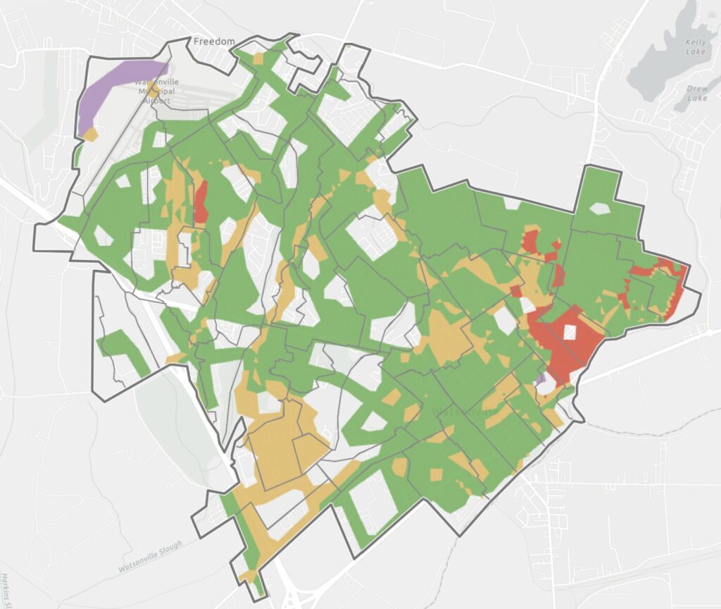
Empowering stormwater teams to leverage the data their MS4 permit requires to go beyond compliance is 2NDNATURE’s secret sauce. As data scientists, 2NDNATURE scientists, and GIS experts get excited about data analysis and visualizations to inform urban planning and land management decisions. By organizing and managing stormwater compliance data using stormwater GIS, a whole world of opportunities and insights are available to urban planners and engineers to use city and drainage scale data to strategically plan where specific practices will yield the greatest benefits. The stormwater manager is able to make the data readily accessible to traffic and parks and engineering to collaborate on city strategies that will boost local climate resilience. The City of Salinas is a great success story, where Heidi has streamlined compliance and turned her focus to address widespread aging and undersized infrastructure and fund solutions that will reduce flooding, recharge local groundwater, protect water quality and uplift their most underserved communities.
Inspiring Large Landowners and Developers
Across the U.S. MS4 permits include new and redevelopment requirements that require the inclusion of stormwater controls when a local city or county issues a building permit that includes land disturbance or the addition of impervious surfaces over a certain size threshold. With thousands of structural stormwater controls inventoried by users in 2NFORM, nearly 75% of these assets are privately owned and maintained. While the details vary, the local municipality that issued the building permit is responsible to ensure private stormwater assets are inspected and maintained per agreements upon building approvals.
Today, private landowners and developers view stormwater development requirements as unavoidable financial costs. 2NDNATURE has partnered with The Nature Conservancy to transform this perception of rain and runoff management from a burden to an asset. Rainsteward allows users to inventory and benchmark the stormwater impact and benefit opportunity of all properties in their portfolio. It makes setting rain and runoff goals and objectives simple so they can evaluate which properties are most suited to efficiently achieve their goals. It is specifically designed to bring efficiencies and data to new and redevelopment projects for private landowners to reduce costs and maximize both financial and community returns. Rainsteward is a tool to allow developers to turn required stormwater investments into a valuable component of their ESG program, complete with defensible accounting and reporting summaries. Check out 5 Steps to Build a Resilient Rainwater Program at Your Company to learn more.
Collaborating for Water Resilience
The importance of sustainable and resilient water management strategies has never been more critical as we confront the increasing frequency and severity of climate-related water crises. 2NDNATURE’s work exemplifies the powerful role of innovative technologies and scientific advancements in transforming the information available to rethink urban rain and stormwater management. By leveraging cutting-edge tools like the TELR model and the comprehensive GIS-based stormwater management framework, 2NDNATURE is not only addressing immediate challenges but is also paving the way for future generations to inherit a healthier, more sustainable environment.
The synthesis of big data, geospatial analytics, and peer-reviewed scientific methods has enabled communities to adopt more effective water management practices that reduce risks and enhance the quality of urban living. These tools help bridge the gap between current practices and the necessary strides towards sustainability and resilience in the face of a changing climate.
Call to Action
As we move forward, it is imperative for all stakeholders, including policymakers, urban planners, developers, and community members, to embrace and integrate these innovative stormwater management solutions into their daily practices and long-term planning.
- Explore and Implement: Municipal leaders and decision-makers are urged to explore the extensive resources and tools provided by 2NDNATURE to understand the specific needs and opportunities within their locales for better water management.
- Invest in Technology and Training: Investing in the right technology and training personnel to utilize these innovative tools effectively will be crucial for maximizing their benefits, ensuring sustainable urban development, and mitigating the impacts of climate change.
- Collaborate and Innovate: Collaboration between the public and private sectors can unlock potential solutions that are both sustainable and economically viable. Sharing insights, challenges, and successes can lead to more robust and community-focused outcomes.
- Advocate and Educate: Community members and local organizations should advocate for proactive measures in stormwater management and educate others about the benefits of sustainable practices, such as rainwater capture and green infrastructure, to foster wider adoption.
Together, by adopting and advocating for these advanced stormwater management strategies, we can ensure a resilient future, mitigate the impacts of climate change, and enhance the quality of life in our urban centers. Join 2NDNATURE in rethinking our approach to urban water management and taking decisive action today for a sustainable tomorrow.